- Home
- →
- Attractions
- →
- Geodetic point «Chekuck»
Geodetic point «Chekuck»
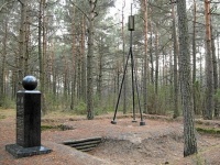
Geodetic Point "Chekutsк" in the Brest region is one of the most important elements of the Struve Arc, included in the UNESCO World Heritage List. This international network of triangulation points, created in the 19th century, played a key role in accurately determining the size and shape of the Earth. Out of the original 265 points, only 34 have been preserved to this day, and Belarus is proud to have 19 of these objects on its territory – more than any other country. In "Chekutsк," a memorial obelisk with a globe and a metal geodetic pyramid has been installed, attracting tourists and researchers.
History of Creation
The Struve Arc was created between 1816 and 1855 under the leadership of Russian astronomer Vasily Yakovlevich Struve. This grand measurement system spanned 10 European countries – from Norway to Moldova – and confirmed that the Earth has the shape of an ellipsoid rather than a perfect sphere. Despite changes in the terrain, the difference between modern and historical data is only 3.5 cm, demonstrating the high accuracy of the conducted measurements. The geodetic point "Chekutsк," like other objects of the Arc, has become a symbol of 19th-century scientific achievements.
Excursions with a Tour of the Geodetic Point
For those who want to learn more about geodesy, the history of science, and unique sites in Belarus, excursions around Belarus with a visit to the geodetic point "Chekutsк" are available. This is a great opportunity to see the memorial obelisk, learn about the history of triangulation measurements, and appreciate the scale of the work done by 19th-century scientists. You can book an excursion with a tour of the geodetic point on our website. There is also an option for an excursion from Minsk, including visits to several Struve Arc geodetic points listed as UNESCO heritage sites.