- Home
- →
- Attractions
- →
- Geodetic point «Leskovichi»
Geodetic point «Leskovichi»
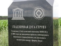
Geodetic Point "Leskovichi" – one of the most important sites of the legendary Struve Arc, included in the UNESCO World Heritage List. This historical monument is part of a unique network of triangulation points stretching across 10 European countries. The arc was created in the 19th century to determine the shape and size of the Earth. Today, the geodetic point "Leskovichi" attracts researchers, tourists, and history enthusiasts, and excursions across Belarus that include a visit to this site provide an opportunity to connect with the scientific heritage of the past.
History of Creation
The Struve Arc was created between 1816 and 1855 under the leadership of Russian astronomer and academician Vasily Yakovlevich Struve. It consisted of 265 geodetic points that were used for precise measurements of the Earth's parameters. The results of these studies proved that the Earth has the shape of an ellipsoid rather than a perfect sphere. Today, only 34 of the original points remain, 19 of which are located in Belarus – more than in any other country. Among the most notable is the geodetic point "Leskovichi," where a commemorative stele in the form of an obelisk with a "globe" has been installed, symbolizing Belarus' contribution to scientific discoveries.
Excursions with a Tour of the Geodetic Point
For history and science enthusiasts, excursions across Belarus that include a visit to the geodetic point "Leskovichi" are available. During the excursion, visitors can learn about the significance of the Struve Arc, the geodetic measurement methods of the 19th century, and see the commemorative markers installed at this historic site. If you want to immerse yourself in the atmosphere of great scientific discoveries, you can book an excursion with a tour of the geodetic point. There are also excursions from Minsk available, allowing visitors to combine a visit to "Leskovichi" with other cultural and natural attractions in the region.