- Home
- →
- Attractions
- →
- Geodetic point «Osovnica»
Geodetic point «Osovnica»
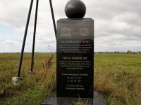
Geodetic Point "Osovnitsa", located in the Brest region, is part of the Struve Arc — a unique scientific system of triangulation measurements from the 19th century, created to determine the shape and size of the Earth. This system includes 265 points passing through 10 countries and has been inscribed on the UNESCO World Heritage List.
Today, only 34 of the original points have been preserved, and Belarus is the leader in the number of preserved sites – there are 19 here, six of which are included in the UNESCO list. "Osovnitsa" is one of these points, which has received additional recognition in the form of a commemorative stele. A four-sided metal pyramid is installed here, and next to it stands an obelisk 1.5 meters high, topped with a 100-kilogram globe with the outline of Belarus. This place not only has historical and scientific significance but is also an interesting site for excursions and educational tourism.
History of Creation
The creation of the Struve Arc took place from 1816 to 1855 and became one of the most significant scientific achievements of the 19th century. The initiator and leader of the measurements was the outstanding Russian astronomer and geodesist Vasily Yakovlevich Struve — an academician and the first director of the Pulkovo Observatory. The main goal of the project was to accurately determine the size and shape of the Earth, which contributed to the development of geodesy and astronomy.
The triangulation method used in the research involved building a system of triangles that allowed distances between points to be measured with high accuracy. One of the key discoveries confirmed by these calculations was the proof that the Earth is not a perfect sphere but an ellipsoid. Remarkably, even after almost 200 years, the difference between the 19th-century measurements and modern data is less than 3.5 cm, which confirms the outstanding quality of the scientific calculations of that time.
Belarus played a key role in the project, as 19 geodetic points were established here — more than in any other country through which the Struve Arc passes. Some points, including "Osovnitsa," have been additionally marked with commemorative signs, making them popular among tourists and researchers.
Excursions with a Tour of the Geodetic Point
Excursions around Belarus with a visit to the geodetic point "Osovnitsa" are a great opportunity to learn about the history of science, geodesy, and unique discoveries of the 19th century. During the trip, you can learn how geodetic measurements were conducted in the past, what instruments were used, and what conclusions scientists drew from the collected data.
For tourists’ convenience, you can book an excursion with a tour of the geodetic point, which may also include visits to other historical sites in the region. If you are in the capital, a tour from Minsk is available, where guides will explain the significance of the Struve Arc and Belarus’s contribution to global scientific progress.
These trips will be interesting not only for history and science enthusiasts but also for anyone who wants to gain a deeper understanding of how Earth studies developed and how complex calculations were made without modern technology. This is a great opportunity to feel part of the world’s scientific heritage and to see one of the most important geodetic sites in Belarus with your own eyes.